
Piégut-Pluviers topographic map
Interactive map
Click on the map to display elevation.
About this map
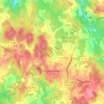
Name: Piégut-Pluviers topographic map, elevation, terrain.
Average elevation: 260 m
Minimum elevation: 200 m
Maximum elevation: 306 m
Other topographic maps
Click on a map to view its topography, its elevation and its terrain.
Coly
France > Nouvelle-Aquitaine > Dordogne > Coly-Saint-Amand
Coly, Coly-Saint-Amand, Sarlat-la-Canéda, Dordogne, Nouvelle-Aquitaine, Metropolitan France, France
Average elevation: 171 m