Geolocate

Redlynch topographic map

Click on the map to display elevation.

About this map

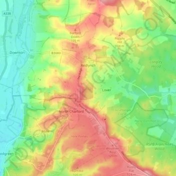
Name: Redlynch topographic map, elevation, terrain.

Location: Redlynch, Wiltshire, England, United Kingdom (50.95021 -1.74806 51.01082 -1.66595)

Average elevation: 74 m

Minimum elevation: 27 m

Maximum elevation: 128 m

Other topographic maps

Click on a map to view its topography, its elevation and its terrain.

Silbury Hill

United Kingdom > England > Wiltshire > Beckhampton

Average elevation: 166 m

Gear up for your next adventure:

🫗Collapsible Water Bottles - Space‑saving hydration
🕶️Polarized Sunglasses - Reduce glare outdoors
🛠️Tent Repair Kits - Fix tents on the trail
🧢Waterproof Caps - Keep rain off your face and glasses while hiking
🌦️Weatherproof Outdoor Gear - Protection from unpredictable weather

As an Amazon Associate, this site earns from qualifying purchases at no extra cost to you.