
Thank you for supporting this site ❤️
Make a donation
Make a donation
Gear up for your next adventure:
As an Amazon Associate, this site earns from qualifying purchases at no extra cost to you.
Côte-d'Or topographic map
Click on the map to display elevation.
Thank you for supporting this site ❤️
Make a donation
Make a donation
Gear up for your next adventure:
As an Amazon Associate, this site earns from qualifying purchases at no extra cost to you.
About this map
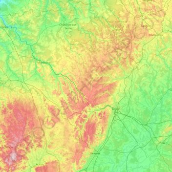
Name: Côte-d'Or topographic map, elevation, terrain.
Location: Côte-d'Or, Bourgogne-Franche-Comté, Metropolitan France, France (46.89986 4.06540 48.03118 5.51887)
Average elevation: 340 m
Minimum elevation: 119 m
Maximum elevation: 902 m
Thank you for supporting this site ❤️
Make a donation
Make a donation
Gear up for your next adventure:
As an Amazon Associate, this site earns from qualifying purchases at no extra cost to you.