
Make a donation
Gear up for your next adventure:
As an Amazon Associate, this site earns from qualifying purchases at no extra cost to you.
Savoy topographic map
Click on the map to display elevation.
Make a donation
Gear up for your next adventure:
As an Amazon Associate, this site earns from qualifying purchases at no extra cost to you.
About this map
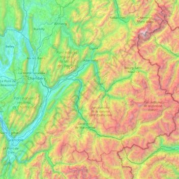
Name: Savoy topographic map, elevation, terrain.
Location: Savoy, Auvergne-Rhône-Alpes, Metropolitan France, France (45.05162 5.62183 45.93852 7.18593)
Average elevation: 1,514 m
Minimum elevation: 190 m
Maximum elevation: 4,728 m
Make a donation
Gear up for your next adventure:
As an Amazon Associate, this site earns from qualifying purchases at no extra cost to you.
Other topographic maps
Click on a map to view its topography, its elevation and its terrain.
Val Thorens
France > Auvergne-Rhône-Alpes > Savoy > Val Thorens
The resort hosted a Tour de France stage finish in 1994. Nelson Rodriguez of Colombia won the stage, which had the second highest elevation for a stage finish in the history of the Tour de France.
Average elevation: 2,516 m