
Make a donation
Gear up for your next adventure:
As an Amazon Associate, this site earns from qualifying purchases at no extra cost to you.
Kaber topographic map
Click on the map to display elevation.
Make a donation
Gear up for your next adventure:
As an Amazon Associate, this site earns from qualifying purchases at no extra cost to you.
About this map
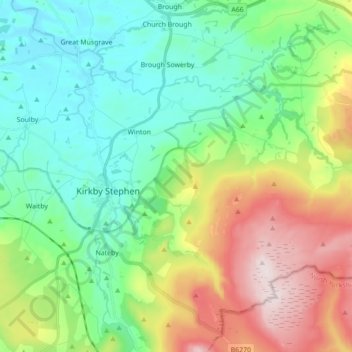
Name: Kaber topographic map, elevation, terrain.
Location: Kaber, Eden District, Cumbria, England, United Kingdom (54.44854 -2.33402 54.50662 -2.15937)
Average elevation: 305 m
Minimum elevation: 139 m
Maximum elevation: 661 m
Make a donation
Gear up for your next adventure:
As an Amazon Associate, this site earns from qualifying purchases at no extra cost to you.
Other topographic maps
Click on a map to view its topography, its elevation and its terrain.
Black Fell Moss
United Kingdom > England > Cumbria > Eden District > Mallerstang
Average elevation: 588 m
Smardale
United Kingdom > England > Cumbria > Eden District > Waitby > Smardale
Average elevation: 247 m
Make a donation
Gear up for your next adventure:
As an Amazon Associate, this site earns from qualifying purchases at no extra cost to you.
Dufton Pike
United Kingdom > England > Cumbria > Eden District
Dufton Pike is a hill in the northern Pennines, in Cumbria, England. It is classed as a Marilyn (a hill with topographic prominence of at least 150m). It rises above the village of Dufton.
Average elevation: 313 m
Make a donation
Gear up for your next adventure:
As an Amazon Associate, this site earns from qualifying purchases at no extra cost to you.