
Make a donation
Gear up for your next adventure:
As an Amazon Associate, this site earns from qualifying purchases at no extra cost to you.
Nakusp topographic map
Click on the map to display elevation.
Make a donation
Gear up for your next adventure:
As an Amazon Associate, this site earns from qualifying purchases at no extra cost to you.
About this map
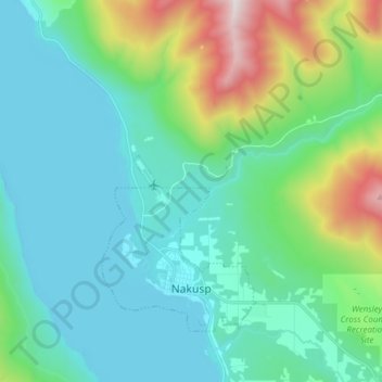
Name: Nakusp topographic map, elevation, terrain.
Average elevation: 752 m
Minimum elevation: 424 m
Maximum elevation: 2,027 m
Make a donation
Gear up for your next adventure:
As an Amazon Associate, this site earns from qualifying purchases at no extra cost to you.
Other topographic maps
Click on a map to view its topography, its elevation and its terrain.
Krestova
Canada > British Columbia > Regional District of Central Kootenay > Area H (The Slocan Valley)
Average elevation: 640 m
Crawford Bay
Canada > British Columbia > Regional District of Central Kootenay > Area A (Wynndel/Crawford Bay/Riondel)
Average elevation: 667 m
Boswell
Canada > British Columbia > Regional District of Central Kootenay > Area A (Wynndel/Crawford Bay/Riondel)
Average elevation: 779 m
Blewett
Canada > British Columbia > Regional District of Central Kootenay > Area E (Balfour/Cottonwood Lake) > Blewett
Average elevation: 837 m
Make a donation
Gear up for your next adventure:
As an Amazon Associate, this site earns from qualifying purchases at no extra cost to you.
Goat River
Canada > British Columbia > Regional District of Central Kootenay > Area B (Goat River Valley)
Average elevation: 1,713 m
Silent Pass
Canada > British Columbia > Regional District of Central Kootenay > Area D (Lardeau Valley/Duncan Lake)
Average elevation: 2,100 m
Cooper Creek
Canada > British Columbia > Regional District of Central Kootenay > Area D (Lardeau Valley/Duncan Lake)
Average elevation: 1,573 m
Keen Creek
Canada > British Columbia > Regional District of Central Kootenay > Area D (Lardeau Valley/Duncan Lake)
Average elevation: 976 m
Make a donation
Gear up for your next adventure:
As an Amazon Associate, this site earns from qualifying purchases at no extra cost to you.
Ymir
Canada > British Columbia > Regional District of Central Kootenay > Area G (Salmo Valley)
Average elevation: 967 m
Burton (Trout) Creek
Canada > British Columbia > Regional District of Central Kootenay > Area K (The Arrow Lakes)
Average elevation: 1,659 m
Passmore
Canada > British Columbia > Regional District of Central Kootenay > Area H (The Slocan Valley)
Average elevation: 819 m
Winlaw
Canada > British Columbia > Regional District of Central Kootenay > Area H (The Slocan Valley)
Average elevation: 694 m
Make a donation
Gear up for your next adventure:
As an Amazon Associate, this site earns from qualifying purchases at no extra cost to you.
Procter
Canada > British Columbia > Regional District of Central Kootenay > Area E (Balfour/Cottonwood Lake)
Average elevation: 715 m
Shoreacres
Canada > British Columbia > Regional District of Central Kootenay > Area I (Sentinel Mountain)
Average elevation: 632 m
Kingsgate
Canada > British Columbia > Regional District of Central Kootenay > Area B (Goat River Valley)
Average elevation: 979 m
Rockslide Lake
Canada > British Columbia > Regional District of Central Kootenay > Area F (Kokanee Range)
Average elevation: 1,605 m
Make a donation
Gear up for your next adventure:
As an Amazon Associate, this site earns from qualifying purchases at no extra cost to you.
Gibson Creek
Canada > British Columbia > Regional District of Central Kootenay > Area I (Sentinel Mountain)
Average elevation: 778 m
Vallican
Canada > British Columbia > Regional District of Central Kootenay > Area H (The Slocan Valley)
Average elevation: 821 m
Castlegar
Canada > British Columbia > Regional District of Central Kootenay > Castlegar
Average elevation: 1,207 m
Ainsworth Hot Springs
Canada > British Columbia > Regional District of Central Kootenay > Area D (Lardeau Valley/Duncan Lake)
Average elevation: 741 m
Make a donation
Gear up for your next adventure:
As an Amazon Associate, this site earns from qualifying purchases at no extra cost to you.
Kitchener
Canada > British Columbia > Regional District of Central Kootenay > Area B (Goat River Valley)
Average elevation: 925 m
Pass Creek
Canada > British Columbia > Regional District of Central Kootenay > Area I (Sentinel Mountain)
Average elevation: 751 m
Kootenay Canal
Canada > British Columbia > Regional District of Central Kootenay > Nelson
Average elevation: 663 m
Stoney Creek
Canada > British Columbia > Regional District of Central Kootenay > Area K (The Arrow Lakes)
Average elevation: 1,295 m
Make a donation
Gear up for your next adventure:
As an Amazon Associate, this site earns from qualifying purchases at no extra cost to you.
Taghum
Canada > British Columbia > Regional District of Central Kootenay > Area F (Kokanee Range)
Average elevation: 745 m
Poplar Creek
Canada > British Columbia > Regional District of Central Kootenay > Area D (Lardeau Valley/Duncan Lake)
Average elevation: 1,732 m
Granite
Canada > British Columbia > Regional District of Central Kootenay > Area E (Balfour/Cottonwood Lake) > Blewett
Average elevation: 772 m
Mount Nemo
Canada > British Columbia > Regional District of Central Kootenay > Area D (Lardeau Valley/Duncan Lake)
Average elevation: 2,283 m
Make a donation
Gear up for your next adventure:
As an Amazon Associate, this site earns from qualifying purchases at no extra cost to you.
South Slocan
Canada > British Columbia > Regional District of Central Kootenay > Area H (The Slocan Valley)
Average elevation: 578 m
Nelway
Canada > British Columbia > Regional District of Central Kootenay > Area G (Salmo Valley)
Average elevation: 924 m
Sandon
Canada > British Columbia > Regional District of Central Kootenay > Area H (The Slocan Valley)
Average elevation: 1,529 m
Make a donation
Gear up for your next adventure:
As an Amazon Associate, this site earns from qualifying purchases at no extra cost to you.
Riondel
Canada > British Columbia > Regional District of Central Kootenay > Area A (Wynndel/Crawford Bay/Riondel)
Average elevation: 675 m
Harrop
Canada > British Columbia > Regional District of Central Kootenay > Area E (Balfour/Cottonwood Lake)
Average elevation: 675 m
Raspberry
Canada > British Columbia > Regional District of Central Kootenay > Area J (Lower Arrow/Columbia)
Average elevation: 651 m
Butters Lake
Canada > British Columbia > Regional District of Central Kootenay > Area D (Lardeau Valley/Duncan Lake)
Average elevation: 2,133 m
Make a donation
Gear up for your next adventure:
As an Amazon Associate, this site earns from qualifying purchases at no extra cost to you.
Crescent Valley
Canada > British Columbia > Regional District of Central Kootenay > Area H (The Slocan Valley)
Average elevation: 602 m
Mazinaw Mountain
Canada > British Columbia > Regional District of Central Kootenay > Area D (Lardeau Valley/Duncan Lake)
Average elevation: 2,578 m
Lemon Creek
Canada > British Columbia > Regional District of Central Kootenay > Area H (The Slocan Valley)
Average elevation: 1,527 m
Playmor Junction
Canada > British Columbia > Regional District of Central Kootenay > Area H (The Slocan Valley) > South Slocan
Average elevation: 578 m
Make a donation
Gear up for your next adventure:
As an Amazon Associate, this site earns from qualifying purchases at no extra cost to you.
Goatfell
Canada > British Columbia > Regional District of Central Kootenay > Area B
Average elevation: 975 m
Kokanee Creek
Canada > British Columbia > Regional District of Central Kootenay > Area E (Balfour/Cottonwood Lake)
Average elevation: 2,022 m
Burton
Canada > British Columbia > Regional District of Central Kootenay > Area K (The Arrow Lakes)
Average elevation: 578 m
Bentz Peak
Canada > British Columbia > Regional District of Central Kootenay > Area J (Lower Arrow/Columbia)
Average elevation: 2,037 m
Make a donation
Gear up for your next adventure:
As an Amazon Associate, this site earns from qualifying purchases at no extra cost to you.
Columbia River
Canada > British Columbia > Regional District of Central Kootenay > Castlegar
Average elevation: 598 m
Balfour
Canada > British Columbia > Regional District of Central Kootenay > Area E (Balfour/Cottonwood Lake)
Average elevation: 673 m
Erickson
Canada > British Columbia > Regional District of Central Kootenay > Area B (Goat River Valley)
Average elevation: 680 m
Commonwealth Mountain
Canada > British Columbia > Regional District of Central Kootenay > Area G (Salmo Valley)
Average elevation: 1,871 m
Make a donation
Gear up for your next adventure:
As an Amazon Associate, this site earns from qualifying purchases at no extra cost to you.
Hall Creek
Canada > British Columbia > Regional District of Central Kootenay > Area G (Salmo Valley)
Average elevation: 1,570 m
Procter
Canada > British Columbia > Regional District of Central Kootenay > Area E (Balfour/Cottonwood Lake)
Average elevation: 715 m