
Make a donation
Gear up for your next adventure:
As an Amazon Associate, this site earns from qualifying purchases at no extra cost to you.
Bragança topographic map
Click on the map to display elevation.
Make a donation
Gear up for your next adventure:
As an Amazon Associate, this site earns from qualifying purchases at no extra cost to you.
Bragança
In 1442, King Afonso V established the hereditary dukedom of the Duchy of Braganza, for his uncle Afonso, Count of Barcelos, becoming one of the oldest fiefdoms in Portugal. The second Duke of Braganza, Fernando, reinforced his grandfather's frontier strategy and expanded his territory by integrating the lands of his deceased brother Afonso, Marquis of Valença. Ferdinand supported King Afonso V of Portugal, and during his North African campaigns, became the Governor of Ceuta. Ferdinand was responsible for ensuring the elevation of Braganza to the status of city (on 20 February 1464), and was Regent when Afonso V returned to North Africa. But his conspiracies and court intrigues during the reign of King John II would have him condemned to death, the banning of the House of Braganza and the incorporation of their hereditary lands and titles into the Crown. The lands remained in the hands of the Crown until the reign of Ferdinand of Portugal, when they were offered as a dowry to João Afonso Pimentel on his marriage to Joana Teles de Menezes, half-sister of Queen Leonor Teles.
Make a donation
Gear up for your next adventure:
As an Amazon Associate, this site earns from qualifying purchases at no extra cost to you.
About this map
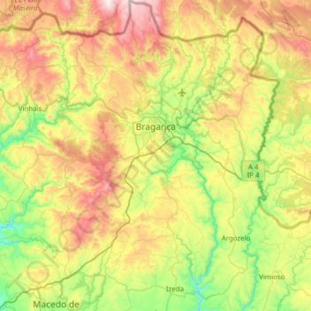
Name: Bragança topographic map, elevation, terrain.
Location: Bragança, Portugal (41.53458 -6.95448 41.99252 -6.51551)
Average elevation: 768 m
Minimum elevation: 313 m
Maximum elevation: 1,539 m
Make a donation
Gear up for your next adventure:
As an Amazon Associate, this site earns from qualifying purchases at no extra cost to you.