
Kappil topographic map
Interactive map
Click on the map to display elevation.
About this map
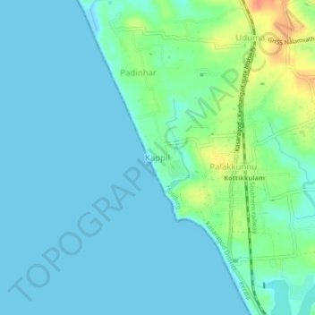
Name: Kappil topographic map, elevation, terrain.
Location: Kappil, Hosdurg, Kasaragod District, Kerala, 671319, India (12.40520 74.99257 12.44520 75.03257)
Average elevation: 10 m
Minimum elevation: -2 m
Maximum elevation: 45 m
Other topographic maps
Click on a map to view its topography, its elevation and its terrain.
Ravaneshwaram
India > Kerala > Hosdurg > Veleswaram
Ravaneshwaram, Veleswaram, Hosdurg, Kasaragod District, Kerala, 671329, India
Average elevation: 26 m
Nileswaram
India > Kerala > Hosdurg > Nileshwaram
Nileswaram, Nileshwaram, Hosdurg, Kasaragod district, Kerala, 670314, India
Average elevation: 16 m
Kanhangad
India > Kerala > Hosdurg > Muriyanavi
Kanhangad, Muriyanavi, Hosdurg, Kasaragod district, Kerala, 671315, India
Average elevation: 19 m
Kottakunnu
India > Kerala > Hosdurg > Kuliyankal
Kottakunnu, Kuliyankal, Hosdurg, Kasaragod district, Kerala, 671315, India
Average elevation: 23 m
Beericheri
Beericheri, Hosdurg, Kasaragod district, Kerala, 671311, India
Average elevation: 7 m
Neeleshwaram
India > Kerala > Hosdurg > Neeleshwaram
Neeleshwaram, Hosdurg, Kasaragod district, Kerala, 670314, India
Average elevation: 14 m