
Rath topographic map
Click on the map to display elevation.
About this map
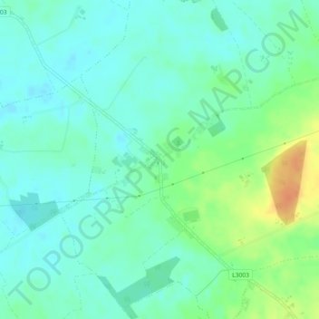
Name: Rath topographic map, elevation, terrain.
Average elevation: 66 m
Minimum elevation: 55 m
Maximum elevation: 92 m
County Offaly trails, hiking, mountain biking, running and outdoor activities
Other topographic maps
Click on a map to view its topography, its elevation and its terrain.
Banagher
There are more than twenty places in Ireland called Banagher or a version thereof. Banagher can be derived as the anglicised version of the Irish 'Beannchor' or 'Beannchar'. Most Irish placenames relate to topographical features and this is the case with 'Beannchor' - in this sense 'beann' refers to or means a…
Average elevation: 44 m