
Lindale topographic map
Click on the map to display elevation.
About this map
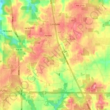
Name: Lindale topographic map, elevation, terrain.
Location: Lindale, Smith County, Texas, 75771, United States (32.45668 -95.45790 32.53230 -95.38082)
Average elevation: 157 m
Minimum elevation: 109 m
Maximum elevation: 187 m
Other topographic maps
Click on a map to view its topography, its elevation and its terrain.
Flint
United States > Texas > Smith County
Flint is an unincorporated community in southeastern Smith County, Texas, United States. It lies along FM 2493, south of the city of Tyler, the county seat of Smith County. Its elevation is 522 feet (159 m). Although Flint is unincorporated, it has a post office, with the ZIP code of 75762.
Average elevation: 146 m