
Make a donation
Gear up for your next adventure:
As an Amazon Associate, this site earns from qualifying purchases at no extra cost to you.
Pontenx-les-Forges topographic map
Click on the map to display elevation.
Make a donation
Gear up for your next adventure:
As an Amazon Associate, this site earns from qualifying purchases at no extra cost to you.
About this map
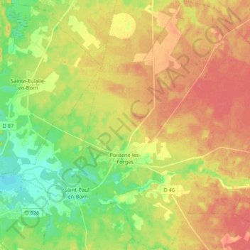
Name: Pontenx-les-Forges topographic map, elevation, terrain.
Average elevation: 33 m
Minimum elevation: 5 m
Maximum elevation: 57 m
Make a donation
Gear up for your next adventure:
As an Amazon Associate, this site earns from qualifying purchases at no extra cost to you.
Other topographic maps
Click on a map to view its topography, its elevation and its terrain.
Les Jardins du Bourg
France > Nouvelle-Aquitaine > Landes > Labenne > Tailleur
Average elevation: 13 m
La Lette
France > Nouvelle-Aquitaine > Landes > Saint-Julien-en-Born > La Lette
Average elevation: 16 m
Make a donation
Gear up for your next adventure:
As an Amazon Associate, this site earns from qualifying purchases at no extra cost to you.