Make a donation
Gear up for your next adventure:
As an Amazon Associate, this site earns from qualifying purchases at no extra cost to you.
Mungkid topographic map
Click on the map to display elevation.
Make a donation
Gear up for your next adventure:
As an Amazon Associate, this site earns from qualifying purchases at no extra cost to you.
About this map
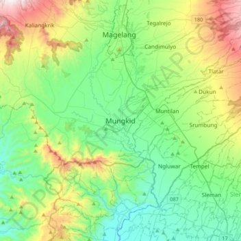
Name: Mungkid topographic map, elevation, terrain.
Location: Mungkid, Magelang, Central Java, Java, 56511, Indonesia (-7.63178 110.17989 -7.55178 110.25989)
Average elevation: 262 m
Minimum elevation: 202 m
Maximum elevation: 416 m
Make a donation
Gear up for your next adventure:
As an Amazon Associate, this site earns from qualifying purchases at no extra cost to you.
Other topographic maps
Click on a map to view its topography, its elevation and its terrain.
Lapangan Paripurno Kecamatan Salaman
Indonesia > Central Java > Magelang > Kembanglimus
Average elevation: 276 m
Make a donation
Gear up for your next adventure:
As an Amazon Associate, this site earns from qualifying purchases at no extra cost to you.
