
Make a donation
Gear up for your next adventure:
As an Amazon Associate, this site earns from qualifying purchases at no extra cost to you.
Sugar Camp topographic map
Click on the map to display elevation.
Make a donation
Gear up for your next adventure:
As an Amazon Associate, this site earns from qualifying purchases at no extra cost to you.
About this map
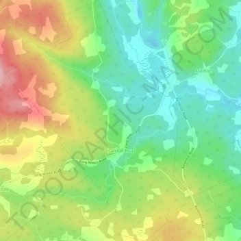
Name: Sugar Camp topographic map, elevation, terrain.
Average elevation: 68 m
Minimum elevation: 4 m
Maximum elevation: 159 m
Make a donation
Gear up for your next adventure:
As an Amazon Associate, this site earns from qualifying purchases at no extra cost to you.
Other topographic maps
Click on a map to view its topography, its elevation and its terrain.
Long Point Provincial Park
Canada > Nova Scotia > Municipality of the County of Inverness > Long Point
Average elevation: 32 m
Upper Glencoe
Canada > Nova Scotia > Municipality of the County of Inverness > Glencoe
Average elevation: 181 m
Meat Cove
Canada > Nova Scotia > Municipality of the County of Inverness > Meat Cove
Average elevation: 117 m
Hawleys Hill
Canada > Nova Scotia > Municipality of the County of Inverness > Mabou
Average elevation: 90 m
Make a donation
Gear up for your next adventure:
As an Amazon Associate, this site earns from qualifying purchases at no extra cost to you.
Mount Young
Canada > Nova Scotia > Municipality of the County of Inverness > Hays River
Average elevation: 185 m