
Maule Region topographic map
Click on the map to display elevation.
About this map
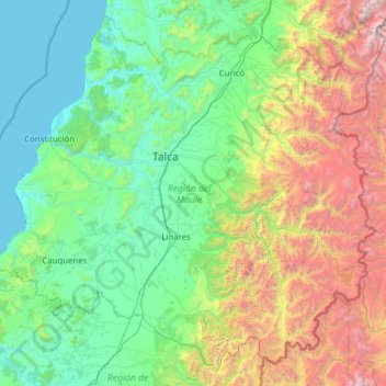
Name: Maule Region topographic map, elevation, terrain.
Location: Maule Region, Chile (-36.54362 -72.78638 -34.68453 -70.30761)
Average elevation: 908 m
Minimum elevation: 0 m
Maximum elevation: 4,855 m
Other topographic maps
Click on a map to view its topography, its elevation and its terrain.
Villa Cerro Castillo
Chile > Aysén Region > Provincia de General Carrera > Río Ibáñez
Average elevation: 379 m
Chair
Chile > Region of Magallanes and Chilean Antarctica > Provincia de la Antártica Chilena > Cape Horn
Average elevation: 18 m
San José de La Mariquina
Chile > Los Ríos Region > Provincia de Valdivia > Mariquina
Average elevation: 32 m
Manzano Amargo
Chile > Maule Region > Provincia de Linares > Linares > Manzano Amargo
Average elevation: 415 m
Volcán San José
Chile > Santiago Metropolitan Region > Provincia de Cordillera > San José de Maipo
Average elevation: 5,462 m