
Culmstock topographic map
Interactive map
Click on the map to display elevation.
About this map
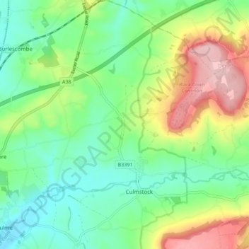
Name: Culmstock topographic map, elevation, terrain.
Location: Culmstock, Mid Devon, Devon, England, Vereinigtes Königreich (50.90172 -3.31471 50.95514 -3.25350)
Average elevation: 147 m
Minimum elevation: 79 m
Maximum elevation: 274 m
Other topographic maps
Click on a map to view its topography, its elevation and its terrain.
Westexe Recreation Ground
Vereinigtes Königreich > England > Devon > Mid Devon > Tiverton
Westexe Recreation Ground, Tiverton, Mid Devon, Devon, England, Vereinigtes Königreich
Average elevation: 104 m