Geolocate

Cason topographic map

Click on the map to display elevation.

About this map

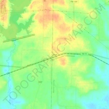
Name: Cason topographic map, elevation, terrain.

Location: Cason, Morris County, Texas, 75636, United States (33.01874 -94.83493 33.05874 -94.79493)

Average elevation: 97 m

Minimum elevation: 79 m

Maximum elevation: 115 m

Other topographic maps

Click on a map to view its topography, its elevation and its terrain.

Lone Star

United States > Texas > Morris County

Average elevation: 102 m

Naples

United States > Texas > Morris County

Average elevation: 116 m

Gear up for your next adventure:

🪑Compact Camping Tables - Tables for campsite comfort
🧤Thermal Outdoor Gloves - Windproof and waterproof gloves for winter hiking
🧣Multi-functional Neckwear - Protect against wind and sun with versatile Buffs
🗺️Irish Road Atlases - Comprehensive physical maps for road trips and navigation
🧴Long-Lasting Sunscreen - Protect against UV rays during long days on the ridges

As an Amazon Associate, this site earns from qualifying purchases at no extra cost to you.