
Make a donation
Gear up for your next adventure:
As an Amazon Associate, this site earns from qualifying purchases at no extra cost to you.
Hadiya topographic map
Click on the map to display elevation.
Make a donation
Gear up for your next adventure:
As an Amazon Associate, this site earns from qualifying purchases at no extra cost to you.
About this map
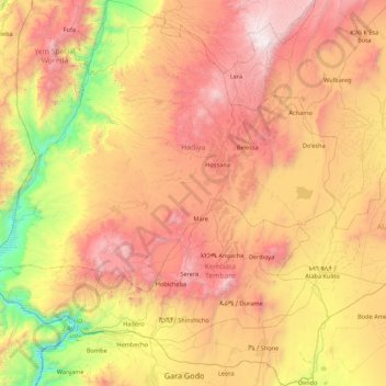
Name: Hadiya topographic map, elevation, terrain.
Location: Hadiya, Central Ethiopia Regional State, Ethiopia (7.05828 37.33198 7.91638 38.12188)
Average elevation: 1,944 m
Minimum elevation: 759 m
Maximum elevation: 3,253 m
Make a donation
Gear up for your next adventure:
As an Amazon Associate, this site earns from qualifying purchases at no extra cost to you.
Other topographic maps
Click on a map to view its topography, its elevation and its terrain.
Hossana
Ethiopia > Central Ethiopia Regional State
Hosaena, Hossana or Hosaina is a town which level as a woreda in southern Ethiopia, and currently serve as the administrative center of Hadiya Zone and Central Ethiopia Regional State as well. Geographically located to the central south of Ethiopia, with a latitude and longitude of 7°33′N 37°51′E /…
Average elevation: 2,255 m
Make a donation
Gear up for your next adventure:
As an Amazon Associate, this site earns from qualifying purchases at no extra cost to you.
Make a donation
Gear up for your next adventure:
As an Amazon Associate, this site earns from qualifying purchases at no extra cost to you.