
Thank you for supporting this site ❤️
Make a donation
Make a donation
Gear up for your next adventure:
As an Amazon Associate, this site earns from qualifying purchases at no extra cost to you.
Rumjatar topographic map
Click on the map to display elevation.
Thank you for supporting this site ❤️
Make a donation
Make a donation
Gear up for your next adventure:
As an Amazon Associate, this site earns from qualifying purchases at no extra cost to you.
About this map
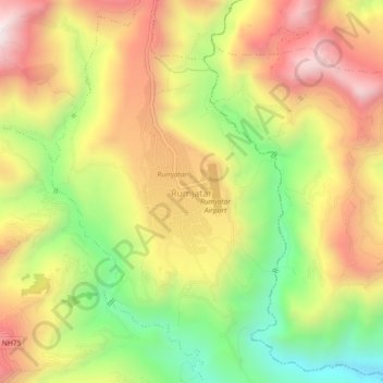
Name: Rumjatar topographic map, elevation, terrain.
Location: Rumjatar, Siddhicharan, Okhaldhunga, Koshi Province, Nepal (27.28222 86.52834 27.32222 86.56834)
Average elevation: 1,263 m
Minimum elevation: 798 m
Maximum elevation: 1,701 m
Thank you for supporting this site ❤️
Make a donation
Make a donation
Gear up for your next adventure:
As an Amazon Associate, this site earns from qualifying purchases at no extra cost to you.
Other topographic maps
Click on a map to view its topography, its elevation and its terrain.