Geolocate

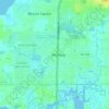
New Port Richey topographic map

Click on the map to display elevation.

About this map

Name: New Port Richey topographic map, elevation, terrain.

Location: New Port Richey, Pasco County, Florida, 34652, United States (28.21930 -82.73999 28.27491 -82.69781)

Average elevation: 5 m

Minimum elevation: -1 m

Maximum elevation: 17 m

Other topographic maps

Click on a map to view its topography, its elevation and its terrain.
Holiday

United States > Florida > Pasco County > Holiday

Average elevation: 5 m

Gear up for your next adventure:

⌚Smart Watches for Hiking - Track performance on trails
🧦Hiking Socks - Comfortable socks to prevent blisters
🧺Waterproof Picnic Blankets - Dry seating for breaks on damp grass
🔋Solar Power Banks - Keep your GPS and phone charged in the Irish wilderness
📟Handheld Altimeters - Track elevation changes and weather patterns accurately

As an Amazon Associate, this site earns from qualifying purchases at no extra cost to you.