
Schwanheim topographic map
Interactive map
Click on the map to display elevation.
About this map
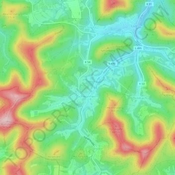
Name: Schwanheim topographic map, elevation, terrain.
Location: Schwanheim, Hauenstein, Südwestpfalz, Rijnland-Palts, Duitsland (49.15259 7.85529 49.18629 7.91181)
Average elevation: 312 m
Minimum elevation: 213 m
Maximum elevation: 473 m
Other topographic maps
Click on a map to view its topography, its elevation and its terrain.
Glastal
Duitsland > Rijnland-Palts > Südwestpfalz > Fischbach bei Dahn
Glastal, Fischbach bei Dahn, Dahner Felsenland, Südwestpfalz, Rijnland-Palts, 66996, Duitsland
Average elevation: 345 m
Dahn
Duitsland > Rijnland-Palts > Südwestpfalz > Dahn
Dahn, Dahner Felsenland, Südwestpfalz, Rijnland-Palts, 66994, Duitsland
Average elevation: 286 m