
Karra topographic map
Interactive map
Click on the map to display elevation.
About this map
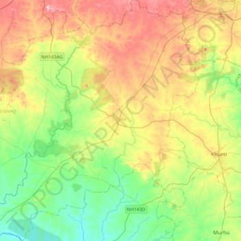
Name: Karra topographic map, elevation, terrain.
Location: Karra, Khunti District, Jharkhand, 835209, India (22.96018 84.93942 23.28542 85.25002)
Average elevation: 608 m
Minimum elevation: 497 m
Maximum elevation: 788 m
Other topographic maps
Click on a map to view its topography, its elevation and its terrain.
Sahibganj
India > Jharkhand > Sahibganj (block)
Sahibganj, Sahibganj (block), Sahibganj District, Jharkhand, 816109, India
Average elevation: 73 m
Ramanagar
India > Jharkhand > Sahibganj (block)
Ramanagar, Sahibganj (block), Sahibganj District, Jharkhand, India
Average elevation: 26 m
Hazaribagh
India > Jharkhand > Hazaribagh
Hazaribagh, Hazaribagh District, Jharkhand, 825300, India
Average elevation: 563 m
Bhuli
India > Jharkhand > Dhanbad-Cum-Kenduadih-Cum-Jagata
Bhuli, Dhanbad-Cum-Kenduadih-Cum-Jagata, Dhanbad District, Jharkhand, 828130, India
Average elevation: 236 m
Charkapatthal
India > Jharkhand > Meral (Pipra Kalan) > Meral
Charkapatthal, Meral, Meral (Pipra Kalan), Garhwa District, Jharkhand, 822139, India
Average elevation: 240 m
Kasi (Gonia)
Kasi (Gonia), Borio, Sahibganj District, Jharkhand, India
Average elevation: 190 m
Garhwa Road
India > Jharkhand > Bishrampur
Garhwa Road, Bishrampur, Palamu District, Jharkhand, India
Average elevation: 184 m
Sordiha
India > Jharkhand > Bishrampur > Bishrampur
Sordiha, Bishrampur, Palamu District, Jharkhand, India
Average elevation: 215 m
Jharia
India > Jharkhand > Jharia-Cum-Jorapokhar-Cum-Sindri
Jharia, Jharia-Cum-Jorapokhar-Cum-Sindri, Dhanbad District, Jharkhand, 828111, India
Average elevation: 192 m
Maithon Reservoir
India > Jharkhand > Jamtara > Mihijam
Maithon Reservoir, Mihijam, Jamtara, Jamtara District, Jharkhand, India
Average elevation: 157 m
Bhawānipur
India > Jharkhand > Chas > Chas
Bhawānipur, Chas, Bokaro District, Jharkhand, 827013, India
Average elevation: 214 m
Samda
India > Jharkhand > Sahibganj (block)
Samda, Sahibganj (block), Sahibganj District, Jharkhand, India
Average elevation: 33 m
Jamshedpur
India > Jharkhand > Golmuri-Cum-Jugsalai
Jamshedpur, Golmuri-Cum-Jugsalai, East Singhbhum District, Jharkhand, 831001, India
Average elevation: 195 m
Tilaiya
India > Jharkhand > Koderma > Jhumri Telaiya
Tilaiya, Jhumri Telaiya, Koderma, Kodarma District, Jharkhand, 825409, India
Average elevation: 392 m
Adityapur
India > Jharkhand > Adityapur(Gamharia)
Adityapur, Adityapur(Gamharia), Seraikela Kharsawan, Jharkhand, 831013, India
Average elevation: 148 m
Dhurwa Dam
Dhurwa Dam, Ranchi, Jharkhand, 834003, India
Average elevation: 663 m
Tagore hill
India > Jharkhand > Kanke > Ranchi
Tagore hill, Ranchi, Kanke, Ranchi, Jharkhand, 834008, India
Average elevation: 640 m
Rock Garden
India > Jharkhand > Kanke > Ranchi
Rock Garden, Pahar Gonda, Ranchi, Kanke, Ranchi, Jharkhand, India
Average elevation: 644 m
Ulihatu
India > Jharkhand > Erki(Tamar II)
Ulihatu, Erki(Tamar II), Khunti, Jharkhand, India
Average elevation: 412 m