
Make a donation
Gear up for your next adventure:
As an Amazon Associate, this site earns from qualifying purchases at no extra cost to you.
Montrose topographic map
Click on the map to display elevation.
Make a donation
Gear up for your next adventure:
As an Amazon Associate, this site earns from qualifying purchases at no extra cost to you.
About this map
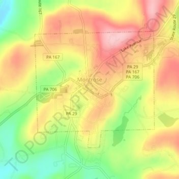
Name: Montrose topographic map, elevation, terrain.
Location: Montrose, Susquehanna County, Pennsylvania, United States (41.82369 -75.88823 41.84125 -75.86404)
Average elevation: 489 m
Minimum elevation: 396 m
Maximum elevation: 565 m
Make a donation
Gear up for your next adventure:
As an Amazon Associate, this site earns from qualifying purchases at no extra cost to you.
Other topographic maps
Click on a map to view its topography, its elevation and its terrain.
Stevens Point
United States > Pennsylvania > Susquehanna County > Harmony Township
Average elevation: 434 m
Brackney
United States > Pennsylvania > Susquehanna County > Silver Lake Township
Average elevation: 491 m
Make a donation
Gear up for your next adventure:
As an Amazon Associate, this site earns from qualifying purchases at no extra cost to you.
Springville
United States > Pennsylvania > Susquehanna County > Springville Township
Average elevation: 389 m
Elkdale
United States > Pennsylvania > Susquehanna County > Clifford Township
Average elevation: 463 m
Woodhouse
United States > Pennsylvania > Susquehanna County > Dimock Township
Average elevation: 416 m
Make a donation
Gear up for your next adventure:
As an Amazon Associate, this site earns from qualifying purchases at no extra cost to you.
Lakeside
United States > Pennsylvania > Susquehanna County > New Milford Township
Average elevation: 478 m
Make a donation
Gear up for your next adventure:
As an Amazon Associate, this site earns from qualifying purchases at no extra cost to you.
Fiddle Lake
United States > Pennsylvania > Susquehanna County > Ararat Township
Average elevation: 609 m
Make a donation
Gear up for your next adventure:
As an Amazon Associate, this site earns from qualifying purchases at no extra cost to you.
Smokey Mountain
United States > Pennsylvania > Susquehanna County > Great Bend Township
Average elevation: 359 m