
El Torno topographic map
Interactive map
Click on the map to display elevation.
About this map
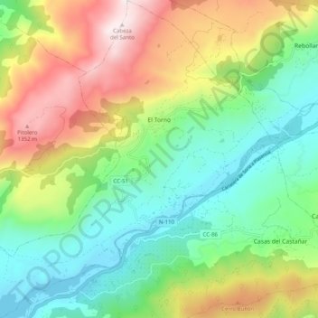
Name: El Torno topographic map, elevation, terrain.
Location: El Torno, Cáceres, Extremadura, España (40.08895 -6.00005 40.16455 -5.91007)
Average elevation: 769 m
Minimum elevation: 361 m
Maximum elevation: 1,479 m
Other topographic maps
Click on a map to view its topography, its elevation and its terrain.
La Cumbre
España > Extremadura > Trujillo
La Cumbre, Trujillo, Cáceres, Extremadura, 10270, España
Average elevation: 426 m
La Cumbre
España > Extremadura > La Cumbre
La Cumbre, Trujillo, Cáceres, Extremadura, 10270, España
Average elevation: 469 m
Badajoz
España > Extremadura > Badajoz
Badajoz, Tierra de Badajoz, Badajoz, Extremadura, España
Average elevation: 185 m
Parque Nacional de Monfragüe
España > Extremadura > Torrejón el Rubio
Parque Nacional de Monfragüe, Calleja larga, Torrejón el Rubio, Cáceres, Extremadura, España
Average elevation: 351 m