
Make a donation
Gear up for your next adventure:
As an Amazon Associate, this site earns from qualifying purchases at no extra cost to you.
Wasenhof topographic map
Click on the map to display elevation.
Make a donation
Gear up for your next adventure:
As an Amazon Associate, this site earns from qualifying purchases at no extra cost to you.
About this map
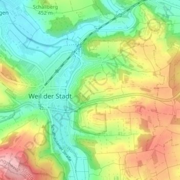
Name: Wasenhof topographic map, elevation, terrain.
Average elevation: 444 m
Minimum elevation: 381 m
Maximum elevation: 540 m
Make a donation
Gear up for your next adventure:
As an Amazon Associate, this site earns from qualifying purchases at no extra cost to you.
Other topographic maps
Click on a map to view its topography, its elevation and its terrain.
Münklingen
Deutschland > Baden-Württemberg > Landkreis Böblingen > Weil der Stadt
Average elevation: 492 m
Merklingen
Deutschland > Baden-Württemberg > Landkreis Böblingen > Weil der Stadt
Die romanische Kirche war vor dem Brand vermutlich dreischiffig mit einem höheren Mittelschiff, einer Apsis als Altarraum unter dem Turm, vielleicht mit einem kleinen, davor eingeschobenen Querhaus. Der spätgotische Bau, „ein Stückwerk aus verschiedenen Bauepochen“ wurde 1425 begonnen und 1776…
Average elevation: 439 m
71263
Deutschland > Baden-Württemberg > Landkreis Böblingen > Weil der Stadt > Merklingen
Average elevation: 463 m