
Schwalenberg topographic map
Interactive map
Click on the map to display elevation.
About this map
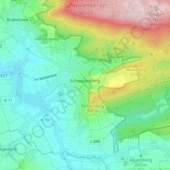
Name: Schwalenberg topographic map, elevation, terrain.
Average elevation: 239 m
Minimum elevation: 149 m
Maximum elevation: 452 m
Other topographic maps
Click on a map to view its topography, its elevation and its terrain.
Vogelhorst
Deutschland > Nordrhein-Westfalen > Kreis Lippe > Lemgo > Voßheide
Vogelhorst, Voßheide, Lemgo, Kreis Lippe, Nordrhein-Westfalen, 32657, Deutschland
Average elevation: 143 m
Rischenau
Deutschland > Nordrhein-Westfalen > Kreis Lippe
Rischenau, Lügde, Kreis Lippe, Nordrhein-Westfalen, Deutschland
Average elevation: 258 m
Heidelbeck
Deutschland > Nordrhein-Westfalen > Kreis Lippe
Heidelbeck, Kalletal, Kreis Lippe, Nordrhein-Westfalen, Deutschland
Average elevation: 216 m
Stemmen
Deutschland > Nordrhein-Westfalen > Kreis Lippe
Stemmen, Kalletal, Kreis Lippe, Nordrhein-Westfalen, Deutschland
Average elevation: 80 m
Extertal
Deutschland > Nordrhein-Westfalen > Kreis Lippe
Extertal, Kreis Lippe, Nordrhein-Westfalen, 32699, Deutschland
Average elevation: 228 m
Harkemissen
Deutschland > Nordrhein-Westfalen > Kreis Lippe
Harkemissen, Kalletal, Kreis Lippe, Nordrhein-Westfalen, 32689, Deutschland
Average elevation: 206 m
Bösingfeld
Deutschland > Nordrhein-Westfalen > Kreis Lippe
Bösingfeld, Extertal, Kreis Lippe, Nordrhein-Westfalen, Deutschland
Average elevation: 247 m
Lemgo
Deutschland > Nordrhein-Westfalen > Kreis Lippe
Lemgo, Kreis Lippe, Nordrhein-Westfalen, 32657, Deutschland
Average elevation: 173 m
Kalletal
Deutschland > Nordrhein-Westfalen > Kreis Lippe
Kalletal, Kreis Lippe, Nordrhein-Westfalen, 32689, Deutschland
Average elevation: 175 m
Bruch
Deutschland > Nordrhein-Westfalen > Kreis Lippe > Hohenhausen
Bruch, Hohenhausen, Kalletal, Kreis Lippe, Nordrhein-Westfalen, 32689, Deutschland
Average elevation: 199 m
Hohenhausen
Deutschland > Nordrhein-Westfalen > Kreis Lippe
Hohenhausen, Kalletal, Kreis Lippe, Nordrhein-Westfalen, 32689, Deutschland
Average elevation: 201 m
Klüt
Deutschland > Nordrhein-Westfalen > Kreis Lippe > Detmold
Klüt, Detmold, Kreis Lippe, Nordrhein-Westfalen, Deutschland
Average elevation: 187 m
Papenhausen
Deutschland > Nordrhein-Westfalen > Kreis Lippe > Bad Salzuflen
Papenhausen, Bad Salzuflen, Kreis Lippe, Nordrhein-Westfalen, Deutschland
Average elevation: 147 m
Schling
Deutschland > Nordrhein-Westfalen > Kreis Lippe > Detmold
Schling, Detmold, Kreis Lippe, Nordrhein-Westfalen, 32760, Deutschland
Average elevation: 255 m
Berlebeck
Deutschland > Nordrhein-Westfalen > Kreis Lippe > Detmold
Berlebeck, Detmold, Kreis Lippe, Nordrhein-Westfalen, Deutschland
Average elevation: 296 m
Dörentrup
Deutschland > Nordrhein-Westfalen > Kreis Lippe
Dörentrup, Kreis Lippe, Nordrhein-Westfalen, 32694, Deutschland
Average elevation: 213 m
Selbeck
Deutschland > Nordrhein-Westfalen > Kreis Lippe > Barntrup
Selbeck, Barntrup, Kreis Lippe, Nordrhein-Westfalen, 32825, Deutschland
Average elevation: 219 m
Bad Salzuflen
Deutschland > Nordrhein-Westfalen > Kreis Lippe
Bad Salzuflen, Kreis Lippe, Nordrhein-Westfalen, Deutschland
Average elevation: 119 m
Detmold
Deutschland > Nordrhein-Westfalen > Kreis Lippe
Detmold, Kreis Lippe, Nordrhein-Westfalen, Deutschland
Average elevation: 202 m
Schlangen
Deutschland > Nordrhein-Westfalen > Kreis Lippe > Schlangen
Schlangen, Kreis Lippe, Nordrhein-Westfalen, 33189, Deutschland
Average elevation: 220 m