
La Casina topographic map
Interactive map
Click on the map to display elevation.
About this map
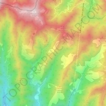
Name: La Casina topographic map, elevation, terrain.
Location: La Casina, San Giustino, Perugia, Umbria, 06016, Italia (43.55300 12.25408 43.59300 12.29408)
Average elevation: 761 m
Minimum elevation: 455 m
Maximum elevation: 1,064 m
Other topographic maps
Click on a map to view its topography, its elevation and its terrain.
Bagnaia
Italia > Umbria > Perugia > San Giustino
Bagnaia, San Giustino, Perugia, Umbria, 06016, Italia
Average elevation: 315 m
Selci-Lama
Italia > Umbria > Perugia > San Giustino
Selci-Lama, San Giustino, Perugia, Umbria, 06016, Italia
Average elevation: 310 m