
Make a donation
Gear up for your next adventure:
As an Amazon Associate, this site earns from qualifying purchases at no extra cost to you.
Monroe Township topographic map
Click on the map to display elevation.
Make a donation
Gear up for your next adventure:
As an Amazon Associate, this site earns from qualifying purchases at no extra cost to you.
About this map
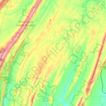
Name: Monroe Township topographic map, elevation, terrain.
Location: Monroe Township, Bedford County, Pennsylvania, United States (39.78952 -78.52087 39.96597 -78.26903)
Average elevation: 407 m
Minimum elevation: 243 m
Maximum elevation: 707 m
Make a donation
Gear up for your next adventure:
As an Amazon Associate, this site earns from qualifying purchases at no extra cost to you.
Other topographic maps
Click on a map to view its topography, its elevation and its terrain.
New Enterprise
United States > Pennsylvania > Bedford County > South Woodbury Township
Average elevation: 397 m
Blue Knob
United States > Pennsylvania > Bedford County > Pavia Township
Blue Knob (elevation 3,146 feet (959 m)) is a summit in the eastern United States with a broad dome that is the northernmost 3,000-footer in the Allegheny Mountains. It is the highest point in Bedford County, Pennsylvania.
Average elevation: 792 m
Stiefler Corner
United States > Pennsylvania > Bedford County > Kimmel Township
Average elevation: 520 m
Breezewood
United States > Pennsylvania > Bedford County > East Providence Township
Average elevation: 413 m
Make a donation
Gear up for your next adventure:
As an Amazon Associate, this site earns from qualifying purchases at no extra cost to you.
Texas Corner
United States > Pennsylvania > Bedford County > South Woodbury Township
Average elevation: 462 m
Waterside
United States > Pennsylvania > Bedford County > South Woodbury Township
Average elevation: 431 m
Yellow Creek
United States > Pennsylvania > Bedford County > Hopewell Township > Yellow Creek
Average elevation: 323 m
Make a donation
Gear up for your next adventure:
As an Amazon Associate, this site earns from qualifying purchases at no extra cost to you.
State Line
United States > Pennsylvania > Bedford County > Londonderry Township
Average elevation: 329 m
Chaneysville
United States > Pennsylvania > Bedford County > Southampton Township
Average elevation: 373 m
Make a donation
Gear up for your next adventure:
As an Amazon Associate, this site earns from qualifying purchases at no extra cost to you.
Blue Knob
United States > Pennsylvania > Bedford County > Pavia Township
Blue Knob (elevation 3,146 feet (959 m)) is a summit in the eastern United States with a broad dome that is the northernmost 3,000-footer in the Allegheny Mountains. It is the highest point in Bedford County, Pennsylvania.
Average elevation: 792 m