
Thank you for supporting this site ❤️
Make a donation
Make a donation
Gear up for your next adventure:
As an Amazon Associate, this site earns from qualifying purchases at no extra cost to you.
Rinteln topographic map
Click on the map to display elevation.
Thank you for supporting this site ❤️
Make a donation
Make a donation
Gear up for your next adventure:
As an Amazon Associate, this site earns from qualifying purchases at no extra cost to you.
About this map
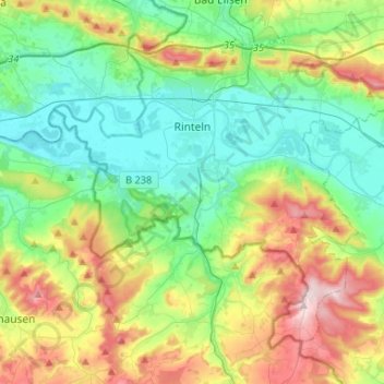
Name: Rinteln topographic map, elevation, terrain.
Location: Rinteln, Landkreis Schaumburg, Nedersaksen, 31737, Duitsland (52.09425 8.98578 52.22594 9.24780)
Average elevation: 152 m
Minimum elevation: 48 m
Maximum elevation: 382 m
Thank you for supporting this site ❤️
Make a donation
Make a donation
Gear up for your next adventure:
As an Amazon Associate, this site earns from qualifying purchases at no extra cost to you.
Other topographic maps
Click on a map to view its topography, its elevation and its terrain.
Wiedenbrügge
Duitsland > Nedersaksen > Landkreis Schaumburg > Wölpinghausen > Wiedenbrügge
Average elevation: 60 m