
Calama topographic map
Click on the map to display elevation.
Calama
The western boundary of the town of Calama is marked by the peaks of the foothills, which occurs north of Calama in the foothills of the Loa River, which has many names, from north to south: Sierra Moreno, Cerros Chuquicamata Cerros de Montecristo. The Cerro Poquis (4,589 m), is the maximum altitude, north of Chuquicamata. South of it begin the foothills of the Cordillera de Domeyko, which in turn serve to chart the southern boundary of the district, with the names of Sierra de Limón Verde and Cordon Barros Arana. The passage of Loa river from east to west leaves a plain, in which the city of Calama and the oasis is located.
About this map
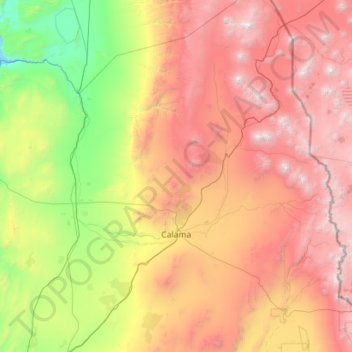
Name: Calama topographic map, elevation, terrain.
Average elevation: 2,653 m
Minimum elevation: 629 m
Maximum elevation: 6,123 m