
Make a donation
Gear up for your next adventure:
As an Amazon Associate, this site earns from qualifying purchases at no extra cost to you.
Bonkle topographic map
Click on the map to display elevation.
Make a donation
Gear up for your next adventure:
As an Amazon Associate, this site earns from qualifying purchases at no extra cost to you.
About this map
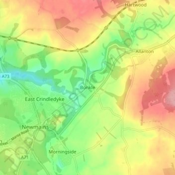
Name: Bonkle topographic map, elevation, terrain.
Location: Bonkle, North Lanarkshire, Scotland, ML2 9QJ, United Kingdom (55.77188 -3.87781 55.81188 -3.83781)
Average elevation: 172 m
Minimum elevation: 116 m
Maximum elevation: 231 m
Make a donation
Gear up for your next adventure:
As an Amazon Associate, this site earns from qualifying purchases at no extra cost to you.
Other topographic maps
Click on a map to view its topography, its elevation and its terrain.
Cumbernauld
United Kingdom > Scotland > North Lanarkshire
Cumbernauld's name probably comes from the Gaelic comar nan allt, meaning "meeting of the burns or streams". There are differing views as to the etymology of this. One theory is that from its high point in the Central Belt, its streams flow both west to the River Clyde and east to the Firth of Forth so…
Average elevation: 113 m
Make a donation
Gear up for your next adventure:
As an Amazon Associate, this site earns from qualifying purchases at no extra cost to you.
Forrestburn Reservoir
United Kingdom > Scotland > North Lanarkshire > Bentfoot
Average elevation: 231 m
Cumbernauld
United Kingdom > Scotland > North Lanarkshire
Cumbernauld's name probably comes from the Gaelic comar nan allt, meaning "meeting of the burns or streams". There are differing views as to the etymology of this. One theory is that from its high point in the Central Belt, its streams flow both west to the River Clyde and east to the Firth of Forth so…
Average elevation: 113 m