
Monte Valmeronte topographic map
Interactive map
Click on the map to display elevation.
About this map
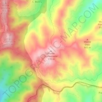
Name: Monte Valmeronte topographic map, elevation, terrain.
Location: Monte Valmeronte, Città di Castello, Perugia, Umbria, Italia (43.56212 12.32347 43.56222 12.32357)
Average elevation: 828 m
Minimum elevation: 645 m
Maximum elevation: 963 m
Other topographic maps
Click on a map to view its topography, its elevation and its terrain.
Promano
Italia > Umbria > Perugia > Città di Castello
Promano, Città di Castello, Perugia, Umbria, 06018, Italia
Average elevation: 288 m
Bocca Serriola
Italia > Umbria > Perugia > Città di Castello
Bocca Serriola, Città di Castello, Perugia, Umbria, Italia
Average elevation: 699 m