
Luhačovice topographic map
Interactive map
Click on the map to display elevation.
About this map
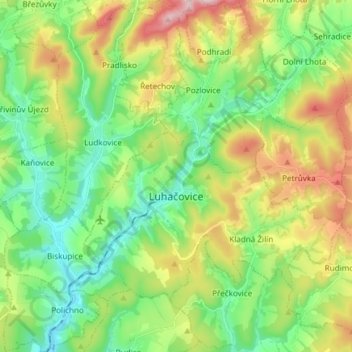
Name: Luhačovice topographic map, elevation, terrain.
Average elevation: 361 m
Minimum elevation: 225 m
Maximum elevation: 619 m
The town occupies the valley of the Luhačovický stream with an elevation of about 250 m above sea level, surrounded by a hilly landscape. The entire municipal territory lies in the Vizovice Highlands, however, the eastern part of the territory extends into the White Carpathians Protected Landscape Region. The highest point of the territory is the hill Brda with an elevation of 600 metres (2,000 ft), located in the area of Řetechov.