
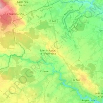
Saint Maurice Étusson topographic map
Interactive map
Click on the map to display elevation.
About this map
Name: Saint Maurice Étusson topographic map, elevation, terrain.
Average elevation: 128 m
Minimum elevation: 77 m
Maximum elevation: 211 m
Other topographic maps
Click on a map to view its topography, its elevation and its terrain.
Fénery
France > Nouvelle-Aquitaine > Deux-Sèvres
Fénery, Parthenay, Deux-Sèvres, Nouvelle-Aquitaine, Metropolitan France, 79450, France
Average elevation: 206 m
Castel Flord
France > Nouvelle-Aquitaine > Deux-Sèvres > Bressuire
Castel Flord, Saint-Sauveur, Bressuire, Deux-Sèvres, Nouvelle-Aquitaine, Metropolitan France, 79300, France
Average elevation: 193 m
Mauléon
France > Nouvelle-Aquitaine > Deux-Sèvres
Mauléon, Bressuire, Deux-Sèvres, Nouvelle-Aquitaine, Metropolitan France, 79700, France
Average elevation: 162 m
La Fragnée
France > Nouvelle-Aquitaine > Deux-Sèvres > Verruyes
La Fragnée, Verruyes, Parthenay, Deux-Sèvres, Nouvelle-Aquitaine, Metropolitan France, 79310, France
Average elevation: 196 m
Moulinade
France > Nouvelle-Aquitaine > Deux-Sèvres > Brioux-sur-Boutonne
Moulinade, Brioux-sur-Boutonne, Niort, Deux-Sèvres, Nouvelle-Aquitaine, Metropolitan France, 79170, France
Average elevation: 64 m
L'Ebaupin
France > Nouvelle-Aquitaine > Deux-Sèvres > Verruyes
L'Ebaupin, Verruyes, Parthenay, Deux-Sèvres, Nouvelle-Aquitaine, Metropolitan France, 79310, France
Average elevation: 193 m
Gachet
France > Nouvelle-Aquitaine > Deux-Sèvres > Melle
Gachet, Saint-Léger-de-la-Martinière, Melle, Niort, Deux-Sèvres, Nouvelle-Aquitaine, Metropolitan France, 79500, France
Average elevation: 139 m
Airvault
France > Nouvelle-Aquitaine > Deux-Sèvres > Airvault
Airvault, Parthenay, Deux-Sèvres, Nouvelle-Aquitaine, Metropolitan France, 79600, France
Average elevation: 113 m
Parthenay
France > Nouvelle-Aquitaine > Deux-Sèvres
Parthenay, Deux-Sèvres, Nouvelle-Aquitaine, Metropolitan France, 79200, France
Average elevation: 161 m