Geolocate

Armagh topographic map

Click on the map to display elevation.

About this map
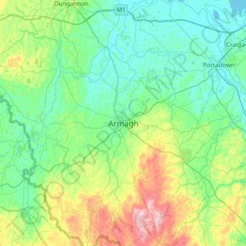
Name: Armagh topographic map, elevation, terrain.

Location: Armagh, Armagh City, Banbridge and Craigavon District, County Armagh, Northern Ireland, BT61 7BU, United Kingdom (54.18820 -6.81404 54.50820 -6.49404)

Average elevation: 85 m

Minimum elevation: 10 m

Maximum elevation: 360 m

Other topographic maps

Click on a map to view its topography, its elevation and its terrain.
Armagh

United Kingdom > Northern Ireland > County Armagh > Armagh

Average elevation: 100 m

Gear up for your next adventure:

🧂Electrolyte Tablets - Stay hydrated during strenuous mountain climbs
🧭Sighting Compasses - Professional grade mirror compass for precise orientation
🧿Outdoor Gadgets - Innovative tools for outdoor enthusiasts
🔭Portable Monoculars - One-handed optics for quick route checking
🎿Skiing Gear - Winter sports essentials

As an Amazon Associate, this site earns from qualifying purchases at no extra cost to you.