
Make a donation
Gear up for your next adventure:
As an Amazon Associate, this site earns from qualifying purchases at no extra cost to you.
East Haddam topographic map
Click on the map to display elevation.
Make a donation
Gear up for your next adventure:
As an Amazon Associate, this site earns from qualifying purchases at no extra cost to you.
About this map
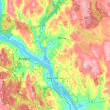
Name: East Haddam topographic map, elevation, terrain.
Average elevation: 96 m
Minimum elevation: 1 m
Maximum elevation: 189 m
Make a donation
Gear up for your next adventure:
As an Amazon Associate, this site earns from qualifying purchases at no extra cost to you.
Other topographic maps
Click on a map to view its topography, its elevation and its terrain.
Johnsonville
United States > Connecticut > Lower Connecticut River Valley Planning Region > East Haddam
Average elevation: 58 m
Hamburg
United States > Connecticut > Lower Connecticut River Valley Planning Region > Lyme
Average elevation: 49 m
Laysville
United States > Connecticut > Lower Connecticut River Valley Planning Region > Old Lyme
Average elevation: 33 m
Fenwood
United States > Connecticut > Lower Connecticut River Valley Planning Region > Old Saybrook
Average elevation: 2 m
Make a donation
Gear up for your next adventure:
As an Amazon Associate, this site earns from qualifying purchases at no extra cost to you.
Hadlyme
United States > Connecticut > Lower Connecticut River Valley Planning Region > Lyme
Average elevation: 45 m
Mount Higby
United States > Connecticut > Lower Connecticut River Valley Planning Region > Middletown
Average elevation: 134 m
Skinnerville
United States > Connecticut > Lower Connecticut River Valley Planning Region > East Hampton
Average elevation: 131 m
Brockway
United States > Connecticut > Lower Connecticut River Valley Planning Region > Lyme
Average elevation: 47 m
Make a donation
Gear up for your next adventure:
As an Amazon Associate, this site earns from qualifying purchases at no extra cost to you.
North Lyme
United States > Connecticut > Lower Connecticut River Valley Planning Region > Lyme
Average elevation: 64 m
Seven Falls
United States > Connecticut > Lower Connecticut River Valley Planning Region > Middletown
Average elevation: 97 m
Johnsonville
United States > Connecticut > Lower Connecticut River Valley Planning Region > East Haddam
Average elevation: 58 m
Bashan
United States > Connecticut > Lower Connecticut River Valley Planning Region > East Haddam
Average elevation: 114 m
Make a donation
Gear up for your next adventure:
As an Amazon Associate, this site earns from qualifying purchases at no extra cost to you.
Essex
United States > Connecticut > Lower Connecticut River Valley Planning Region
Average elevation: 45 m
Oxford Park
United States > Connecticut > Lower Connecticut River Valley Planning Region > Cromwell
Average elevation: 32 m
Arnolds
United States > Connecticut > Lower Connecticut River Valley Planning Region > Haddam
Average elevation: 72 m
Grove Beach
United States > Connecticut > Lower Connecticut River Valley Planning Region > Westbrook
Average elevation: 7 m
Make a donation
Gear up for your next adventure:
As an Amazon Associate, this site earns from qualifying purchases at no extra cost to you.
Knollwood
United States > Connecticut > Lower Connecticut River Valley Planning Region > Old Saybrook
Average elevation: 2 m
Hurd State Park
United States > Connecticut > Lower Connecticut River Valley Planning Region > East Hampton
Average elevation: 76 m
Brazos Quarry Pond
United States > Connecticut > Lower Connecticut River Valley Planning Region > Portland
Average elevation: 20 m
Clinton Beach
United States > Connecticut > Lower Connecticut River Valley Planning Region > Clinton
Average elevation: 4 m
Make a donation
Gear up for your next adventure:
As an Amazon Associate, this site earns from qualifying purchases at no extra cost to you.