
Make a donation
Gear up for your next adventure:
As an Amazon Associate, this site earns from qualifying purchases at no extra cost to you.
Catmon topographic map
Click on the map to display elevation.
Make a donation
Gear up for your next adventure:
As an Amazon Associate, this site earns from qualifying purchases at no extra cost to you.
About this map
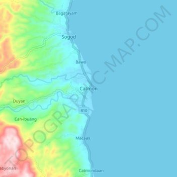
Name: Catmon topographic map, elevation, terrain.
Location: Catmon, Cebu, Central Visayas, 6006, Philippines (10.68382 123.97380 10.76382 124.05380)
Average elevation: 67 m
Minimum elevation: -1 m
Maximum elevation: 442 m
Make a donation
Gear up for your next adventure:
As an Amazon Associate, this site earns from qualifying purchases at no extra cost to you.
Other topographic maps
Click on a map to view its topography, its elevation and its terrain.
Oslob
Generally, topography of the area is hilly and rolling, dominated by open grasslands and second growth forest. There are fairly level and rolling plateaus and valleys spread throughout the interior. These are some of the most suitable areas for upland agriculture. The highest mountain peak is 800 metres (2,600…
Average elevation: 99 m
Make a donation
Gear up for your next adventure:
As an Amazon Associate, this site earns from qualifying purchases at no extra cost to you.
Make a donation
Gear up for your next adventure:
As an Amazon Associate, this site earns from qualifying purchases at no extra cost to you.