
Chengguan District topographic map
Interactive map
Click on the map to display elevation.
About this map
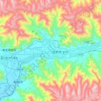
Name: Chengguan District topographic map, elevation, terrain.
Location: Chengguan District, Lhasa, Tibet, 850000, China (29.51215 91.01220 29.80326 91.30094)
Average elevation: 4,325 m
Minimum elevation: 3,614 m
Maximum elevation: 5,654 m
Lhasa is the second most populous urban area on the Tibetan Plateau after Xining and, at an altitude of 3,656 metres (11,990 ft), Lhasa is one of the highest cities in the world. The city has been the religious and administrative capital of Tibet since the mid-17th century. It contains many culturally significant Tibetan Buddhist sites such as the Potala Palace, Jokhang Temple and Norbulingka Palaces.
Other topographic maps
Click on a map to view its topography, its elevation and its terrain.
卡瓦格博观景台
China > Tibet > Zogang County > Pütog
卡瓦格博观景台, 甲应路, Pütog, Zogang County, Chamdo City, Nyingchi Prefecture, Tibet, China
Average elevation: 4,323 m
Shigatse
China > Tibet > Chengdong Subdistrict
Shigatse, Chengdong Subdistrict, Samzhubzê District, Shigatse Prefecture, Tibet, China
Average elevation: 4,055 m
Tibetan Plateau
China > Tibet > Nyima County > 尼玛镇
Tibetan Plateau, 尼玛镇, Nyima County, Nagqu City, Tibet, China
Average elevation: 4,475 m