
Make a donation
Gear up for your next adventure:
As an Amazon Associate, this site earns from qualifying purchases at no extra cost to you.
Borno State topographic map
Click on the map to display elevation.
Make a donation
Gear up for your next adventure:
As an Amazon Associate, this site earns from qualifying purchases at no extra cost to you.
About this map
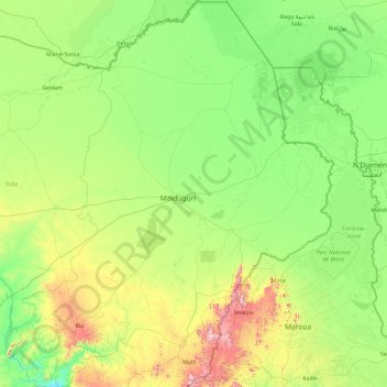
Name: Borno State topographic map, elevation, terrain.
Location: Borno State, Nigeria (10.02218 11.52934 13.72144 14.67801)
Average elevation: 360 m
Minimum elevation: 183 m
Maximum elevation: 1,330 m
Make a donation
Gear up for your next adventure:
As an Amazon Associate, this site earns from qualifying purchases at no extra cost to you.
Other topographic maps
Click on a map to view its topography, its elevation and its terrain.
Omu Aran
Nigeria > Kwara State > Irepodun
Omu Aran has a tropical wet and dry or savanna climate and is located at an elevation of 536.14 meters (1758.99 feet) above sea level (Classification: Aw). The district's average annual temperature is 0.26% higher than Nigeria's averages at 29.72°C (85.5°F). Omu Aran generally has 149.31 wet days per year…
Average elevation: 539 m
Ibadan
Nigeria > Oyo State > Ibadan South West
Ibadan, coined from the phrase "Eba Odan", which literally means 'by the edge of the meadow', came into existence in 1829, during a period of turmoil that characterized Yorubaland at the time. It was in this period that many old Yoruba cities such as old Oyo (Oyo ile), Ijaye and Owu disappeared, and newer ones…
Average elevation: 191 m
Make a donation
Gear up for your next adventure:
As an Amazon Associate, this site earns from qualifying purchases at no extra cost to you.