
Make a donation
Gear up for your next adventure:
As an Amazon Associate, this site earns from qualifying purchases at no extra cost to you.
Peyroche topographic map
Click on the map to display elevation.
Make a donation
Gear up for your next adventure:
As an Amazon Associate, this site earns from qualifying purchases at no extra cost to you.
About this map
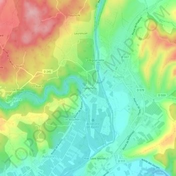
Name: Peyroche topographic map, elevation, terrain.
Average elevation: 153 m
Minimum elevation: 92 m
Maximum elevation: 250 m
Make a donation
Gear up for your next adventure:
As an Amazon Associate, this site earns from qualifying purchases at no extra cost to you.
Other topographic maps
Click on a map to view its topography, its elevation and its terrain.
Ardèche
France > Auvergne-Rhône-Alpes > Ardèche > Labeaume > La Bigournette
De 125,1 km de longueur, elle prend sa source, à 1 467 m d'altitude, dans le Vivarais, près du col de la Chavade, dans la forêt de Mazan sur la commune d’Astet. Après Aubenas et Ruoms, elle reçoit le Chassezac et La Beaume, puis s’enfonce à partir de Vallon-Pont-d’Arc dans les célèbres gorges…
Average elevation: 155 m