
Pretoria topographic map
Interactive map
Click on the map to display elevation.
About this map
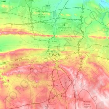
Name: Pretoria topographic map, elevation, terrain.
Average elevation: 1,363 m
Minimum elevation: 1,151 m
Maximum elevation: 1,599 m
Pretoria is situated approximately 55 km (34 mi) north-northeast of Johannesburg in the northeast of South Africa, in a transitional belt between the plateau of the Highveld to the south and the lower-lying Bushveld to the north. It lies at an altitude of about 1,339 m (4,393 ft) above sea level, in a warm, sheltered, fertile valley, surrounded by the hills of the Magaliesberg range.
Other topographic maps
Click on a map to view its topography, its elevation and its terrain.
Centurion
South Africa > Gauteng > City of Tshwane Metropolitan Municipality
Centurion, City of Tshwane Metropolitan Municipality, Gauteng, 0014, South Africa
Average elevation: 1,451 m
Cullinan
South Africa > Gauteng > City of Tshwane Metropolitan Municipality
Cullinan, City of Tshwane Metropolitan Municipality, Gauteng, South Africa
Average elevation: 1,420 m
Bronkhorstspruit
South Africa > Gauteng > City of Tshwane Metropolitan Municipality
Bronkhorstspruit, City of Tshwane Metropolitan Municipality, Gauteng, South Africa
Average elevation: 1,411 m
Akasia
South Africa > Gauteng > City of Tshwane Metropolitan Municipality
Akasia, City of Tshwane Metropolitan Municipality, Gauteng, 0118, South Africa
Average elevation: 1,309 m