
Thank you for supporting this site ❤️
Make a donation
Make a donation
Gear up for your next adventure:
As an Amazon Associate, this site earns from qualifying purchases at no extra cost to you.
Wanfried topographic map
Click on the map to display elevation.
Thank you for supporting this site ❤️
Make a donation
Make a donation
Gear up for your next adventure:
As an Amazon Associate, this site earns from qualifying purchases at no extra cost to you.
About this map
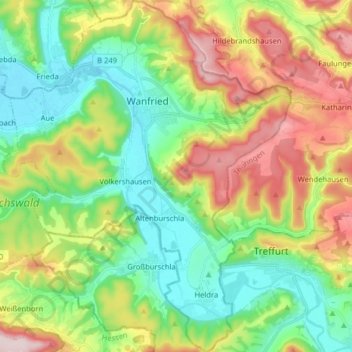
Name: Wanfried topographic map, elevation, terrain.
Location: Wanfried, Werra-Meißner-Kreis, Hessen, 37281, Duitsland (51.11217 10.10573 51.21242 10.23641)
Average elevation: 285 m
Minimum elevation: 160 m
Maximum elevation: 501 m
Thank you for supporting this site ❤️
Make a donation
Make a donation
Gear up for your next adventure:
As an Amazon Associate, this site earns from qualifying purchases at no extra cost to you.
Other topographic maps
Click on a map to view its topography, its elevation and its terrain.
Giesenberg
Duitsland > Hessen > Werra-Meißner-Kreis > Gutsbezirk Kaufunger Wald
Average elevation: 473 m