
Make a donation
Gear up for your next adventure:
As an Amazon Associate, this site earns from qualifying purchases at no extra cost to you.
Luannan County topographic map
Click on the map to display elevation.
Make a donation
Gear up for your next adventure:
As an Amazon Associate, this site earns from qualifying purchases at no extra cost to you.
Luannan County
Luannan County spans an area of 1,482.6 square kilometres (572.4 sq mi). It has a coastline of 29.63 kilometres (18.41 mi), alongside the Bohai Bay. The Luan River runs through the county. The county's elevation is relatively flat, as it is part of an alluvial plain. However, it is higher in the northern portions.
Make a donation
Gear up for your next adventure:
As an Amazon Associate, this site earns from qualifying purchases at no extra cost to you.
About this map
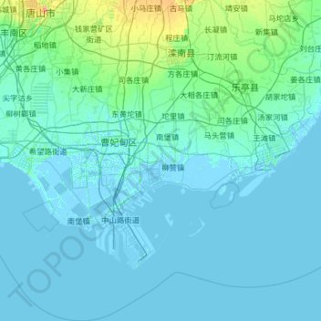
Name: Luannan County topographic map, elevation, terrain.
Location: Luannan County, Tangshan City, Hebei, China (38.77375 118.02388 39.66148 118.85548)
Average elevation: 5 m
Minimum elevation: -4 m
Maximum elevation: 76 m
Make a donation
Gear up for your next adventure:
As an Amazon Associate, this site earns from qualifying purchases at no extra cost to you.