
Make a donation
Gear up for your next adventure:
As an Amazon Associate, this site earns from qualifying purchases at no extra cost to you.
Marmaro topographic map
Click on the map to display elevation.
Make a donation
Gear up for your next adventure:
As an Amazon Associate, this site earns from qualifying purchases at no extra cost to you.
About this map
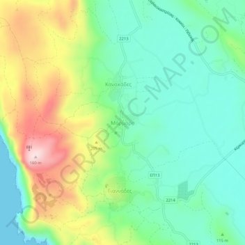
Name: Marmaro topographic map, elevation, terrain.
Average elevation: 120 m
Minimum elevation: -2 m
Maximum elevation: 355 m
Make a donation
Gear up for your next adventure:
As an Amazon Associate, this site earns from qualifying purchases at no extra cost to you.
Other topographic maps
Click on a map to view its topography, its elevation and its terrain.
Τραχειά
Greece > Peloponnese, Western Greece and the Ionian > Corfu Regional Unit > Mathraki Municipal Unit
Average elevation: 2 m
Λάκωνες
Greece > Peloponnese, Western Greece and the Ionian > Corfu Regional Unit
Average elevation: 206 m
Municipal Unit of Meliteieis
Greece > Peloponnese, Western Greece and the Ionian > Corfu Regional Unit
Average elevation: 46 m