
Make a donation
Gear up for your next adventure:
As an Amazon Associate, this site earns from qualifying purchases at no extra cost to you.
Tarbes topographic map
Click on the map to display elevation.
Make a donation
Gear up for your next adventure:
As an Amazon Associate, this site earns from qualifying purchases at no extra cost to you.
Tarbes
Tarbes is a Pre-Pyrenees town within the rich agricultural plain of the river Adour, 155 kilometres (96 miles) southwest of Toulouse, 144 kilometres (89 miles) to the east of Bayonne, 70 kilometres (43 miles) southwest of Auch and 20 kilometres (12 miles) northeast of Lourdes. Tarbes is 1 hr 30 mins from the Atlantic Ocean, 2 hrs 50 mins from the Languedoc coast and 35 minutes from the nearest ski resorts. It is located at an average elevation of 304 metres (997 feet).
Make a donation
Gear up for your next adventure:
As an Amazon Associate, this site earns from qualifying purchases at no extra cost to you.
About this map
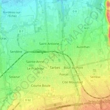
Name: Tarbes topographic map, elevation, terrain.
Average elevation: 308 m
Minimum elevation: 283 m
Maximum elevation: 349 m
Make a donation
Gear up for your next adventure:
As an Amazon Associate, this site earns from qualifying purchases at no extra cost to you.
Other topographic maps
Click on a map to view its topography, its elevation and its terrain.