
Make a donation
Gear up for your next adventure:
As an Amazon Associate, this site earns from qualifying purchases at no extra cost to you.
Harvest topographic map
Click on the map to display elevation.
Make a donation
Gear up for your next adventure:
As an Amazon Associate, this site earns from qualifying purchases at no extra cost to you.
Harvest
Capshaw Mountain (1,250 feet above sea level) is the only notable geological feature in the area, which extends about 800 feet above the general elevation in the area. The top of this small mountain is the site of several substantial communications towers used by local radio stations. Capshaw Mountain forms a watershed that provides the water supply for the community.
Make a donation
Gear up for your next adventure:
As an Amazon Associate, this site earns from qualifying purchases at no extra cost to you.
About this map
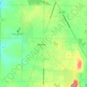
Name: Harvest topographic map, elevation, terrain.
Location: Harvest, Madison County, Alabama, United States (34.83066 -86.78497 34.88213 -86.71371)
Average elevation: 254 m
Minimum elevation: 219 m
Maximum elevation: 314 m
Make a donation
Gear up for your next adventure:
As an Amazon Associate, this site earns from qualifying purchases at no extra cost to you.