
Thank you for supporting this site ❤️
Make a donation
Make a donation
Gear up for your next adventure:
As an Amazon Associate, this site earns from qualifying purchases at no extra cost to you.
Wivenhoe topographic map
Click on the map to display elevation.
Thank you for supporting this site ❤️
Make a donation
Make a donation
Gear up for your next adventure:
As an Amazon Associate, this site earns from qualifying purchases at no extra cost to you.
About this map
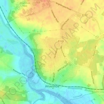
Name: Wivenhoe topographic map, elevation, terrain.
Location: Wivenhoe, Rowhedge, Colchester, Essex, England, United Kingdom (51.85132 0.93929 51.87752 0.97937)
Average elevation: 22 m
Minimum elevation: -1 m
Maximum elevation: 41 m
Thank you for supporting this site ❤️
Make a donation
Make a donation
Gear up for your next adventure:
As an Amazon Associate, this site earns from qualifying purchases at no extra cost to you.