
Thank you for supporting this site ❤️
Make a donation
Make a donation
Gear up for your next adventure:
As an Amazon Associate, this site earns from qualifying purchases at no extra cost to you.
Goodrich topographic map
Click on the map to display elevation.
Thank you for supporting this site ❤️
Make a donation
Make a donation
Gear up for your next adventure:
As an Amazon Associate, this site earns from qualifying purchases at no extra cost to you.
About this map
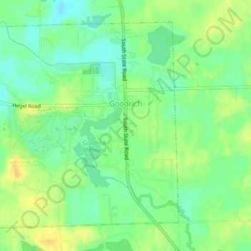
Name: Goodrich topographic map, elevation, terrain.
Location: Goodrich, Genesee County, Michigan, 48438, United States (42.90357 -83.52411 42.92584 -83.49385)
Average elevation: 271 m
Minimum elevation: 258 m
Maximum elevation: 284 m
Thank you for supporting this site ❤️
Make a donation
Make a donation
Gear up for your next adventure:
As an Amazon Associate, this site earns from qualifying purchases at no extra cost to you.
Other topographic maps
Click on a map to view its topography, its elevation and its terrain.
Genessee County Recreational Area
United States > Michigan > Genesee County > Genesee Charter Township
Average elevation: 231 m