
Thank you for supporting this site ❤️
Make a donation
Make a donation
Gear up for your next adventure:
As an Amazon Associate, this site earns from qualifying purchases at no extra cost to you.
Enhulumi topographic map
Click on the map to display elevation.
Thank you for supporting this site ❤️
Make a donation
Make a donation
Gear up for your next adventure:
As an Amazon Associate, this site earns from qualifying purchases at no extra cost to you.
About this map
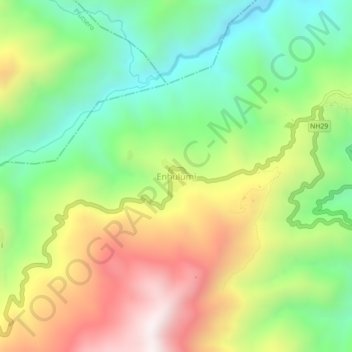
Name: Enhulumi topographic map, elevation, terrain.
Location: Enhulumi, Chizami, Phek, Nagaland, 797102, India (25.56672 94.34706 25.60672 94.38706)
Average elevation: 1,396 m
Minimum elevation: 957 m
Maximum elevation: 2,004 m
Thank you for supporting this site ❤️
Make a donation
Make a donation
Gear up for your next adventure:
As an Amazon Associate, this site earns from qualifying purchases at no extra cost to you.