
Ashford topographic map
Interactive map
Click on the map to display elevation.
About this map
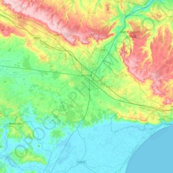
Name: Ashford topographic map, elevation, terrain.
Location: Ashford, Kent, England, United Kingdom (50.98949 0.59030 51.27024 1.02921)
Average elevation: 60 m
Minimum elevation: -2 m
Maximum elevation: 199 m
Other topographic maps
Click on a map to view its topography, its elevation and its terrain.
White Cliffs of Dover
United Kingdom > England > Kent > Dover > St. Margaret's at Cliffe
Average elevation: 49 m
Bedgebury National Pinetum
United Kingdom > England > Kent > Tunbridge Wells > Kilndown
Average elevation: 91 m