
Siquijor topographic map
Interactive map
Click on the map to display elevation.
About this map
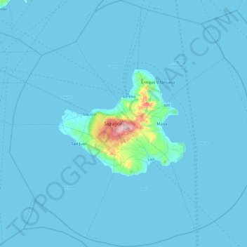
Name: Siquijor topographic map, elevation, terrain.
Location: Siquijor, Central Visayas, Philippines (8.96200 123.35786 9.43584 123.83754)
Average elevation: 17 m
Minimum elevation: 0 m
Maximum elevation: 568 m
The island lies about 19 kilometres (12 mi) east of the nearest point on southern Negros, 25 kilometres (16 mi) southeast of Cebu, 30 kilometres (19 mi) southwest of Bohol, and 45 kilometres (28 mi) north of Zamboanga del Norte in Mindanao. It is predominantly hilly and in many places the hills reach the sea, producing precipitous cliffs. At the center, Mount Malabahoc (locally known as Mount Bandila‑an) reaches about 628 metres (2,060 ft) in elevation, the highest point on the island. Three marine terraces can be roughly traced especially in the vicinity of Tag‑ibo on the southwestern part of the island, a barrio of San Juan municipality from the seacoast up into the central part.